Saturday, June 30, 2012

A visit to Gold Beach, OR

We loved the coast highway, US 101, which travels right up the amazing coast of the Pacific. This route offers some of the most magnificent scenery we have ever seen.

 There are quite a few viewpoints next to the road and we took full advantage of them to explore the area. Fortunately, we had a beautiful day as we headed about 25 miles north of Brookings to Gold Beach.

 One interesting sight is Arch Rock, named for the obvious arch way that has been cut through the rock by the endless wave action of the sea.

 There are huge rocks that extend out well into the Pacific, making for a beautiful contrast with the ocean.

 Rick thought this was great and wondered how this must look when the large waves pound in during the pacific storms.

We saw some signs that warned about high winds that blew in from the ocean. Soon, we began to see trees that were pushed over by constant wind -- we could only imagine how hard and often the wind has to blow to make a tree grow like this. 
Once in Gold Beach, we went down to the dock area and saw this wreck of a tugboat. A bit of investigation revealed that it was the Mary D. Hume, built right here in 1881. Interestingly, after almost 100 years of service in 1978, the ship came here under its own power and was donated to the City of Gold Beach. Unfortunately, a short time later, the ship was lifted out of the water for maintenance, but a sling broke and the ship dropped and was damaged beyond repair. The tug has sat here ever since. 

The sea was not the only thing that provided a great view. We saw many beautiful flowers like this on our drive, as well as incredible ferns and other plants. We had a great day on the southern coast road.


Friday, June 29, 2012

An Ocean Front RV site in Brookings, OR

After a couple nights at our first RV park, we moved a couple hundred yards down to the Beachfront RV Resort. Here Orinda checks out the entry to the park which features this sculpture of the St. George's Reef Lighthouse (this was carved out of a redwood tree trunk).

Beachview RV park is a unique spot and a very interesting place to visit. In fact, we were fortunate enough to get an ocean front full hookup rv site! Pretty cool.

 Looking out of the motorhome windshield, Rick could vaguely see a tower-like shape well out into the Pacific. It turns out that this is the St. George Reef Lighthouse which is over 8 miles away from this point. Even with the telephoto lens, this is a challenging photo. We learned that this was a real engineering challenge and the base of the station is made of carved granite rocks moved from Crescent City, CA.

Fortunately, we found a postcard featuring this lighthouse and Rick was able to get a great picture of it. Imagine working out here where you would work in 3 month shifts operating the lighthouse. Not surprisingly, this was one of the most dangerous lighthouse assignments since it was very difficult for crew members to board the lighthouse from a small ship and several men perished over the years before it was closed in 1975. 

 One of the great things of our location is that this is the view out the motorhome windshield. Rick is delighted to be able to sit in the driver's seat and watch the surf pound in just feet away.

Just a couple hundred feet away from our RV site, the Chetco River empties into the Pacific (on the right side of this picture) while Orinda checks out the jetty protecting the port. 

Facing the other way (looking away from the ocean), we could easily see the Chetco River (to the left) and the boat basin (right). We could also better understand how the tsunami pushed the river outflow back into the boat basin and really compounding the damages from the tsunami.


It is great to be able to walk a few feet to the wide beach and enjoy a walk on the beach. At low tide, we could see the huge rocks that dot the beach and have been worn smooth by the wave action. 

These beaches are much different from beaches we have been on in South Carolina or Florida. Rather, these are very rugged beaches with dark sand, huge rocks, and lots of driftwood. In fact, we were amazed to see these huge trees washed up on the beach. Imagine hitting one of these while running your boat!

Thursday, June 28, 2012

Brookings, Oregon - a very nice town

 We traveled from Eureka, CA to Brookings, OR, which is just north of the California state line. Brookings is a nice town located on the Chetco River and offers a number of different RV parks.  We stayed at the Parkside RV park which is located near the marina.

 Behind our rig was this beautiful hydrangea bush that Orinda really liked. It seems that everything grows great in this temperate climate with plenty of rainfall.

 There is a large marina and boat basin located right across the street from the RV park and a very short way from the Pacific Ocean. We wandered over to the boardwalk to see what was around and see the boats.

  Lo and behold -- a seafood grill right here! And it offers chowder, Rick's favorite.
Rick wondered if the chowder was any good and turning the corner, he saw this sign -- and decided that lunch was in the offing. Turns out that the sign was right -- the chowder was great!

After lunch, we continued to explore the marina, which was filled with boats. We also learned about a calamity that occurred a bit over a year ago. 

 On March 11, 2011 the Japan earthquake caused a tsunami wave that struck the Port of Brookings. We had no idea that an earthquake on one side of the Pacific could cause terrible damage thousands of miles away.

Here is a shot from local press coverage showing a small portion of the damage -- compare this with the shot I took above (for photo reference, see http://www.newslincolncounty.com/?p=18631

 It turns out that the tsunami wave was strong enough to turn back the Chetco River flow (even when swollen with rain) and divert it and the tsunami into the boat basin area. This huge surge of water caused terrific damage to the docks and boats in the area. While this caused millions of dollars of damage, the damage has been fully repaired and the port is once more beautiful.


Wednesday, June 27, 2012

A "Little" Trip Around the Block -- Whew - A Long Day!!

 Orinda noticed this little, innocuous sign while traveling the Avenue of Giants and thought it would be a great side trip. It looked great -- wonderful scenery, ocean views -- but Rick noticed the steep grades and limited services available, but really, how hard could it be?

 The first phase was through huge redwoods on a very narrow road and very sharp curves. Rick was VERY glad he was not in the motorhome on this part of the road!


We began to climb rapidly as we hit the coastal hills (small mountains!), with the road taking some amazing twists and turns. 180 degree switchbacks were nothing, as can be seen by our GPS above. The interesting thing was that this sort of picture was repeated many times during our drive. Fortunately, we were in no hurry and enjoyed the scenery.

We popped out of the ravines to find the mountain top as shown here. The terrain is amazing as we approached the Pacific Ocean and the road, while indeed paved, was very rough, but we had no problem as we took it slow.

Obviously, before we got to the ocean, we had to descend, during which we crossed this old truss bridge. Orinda was a bit surprised at the wood roadway and Rick thought that yet again, he was delighted to be in the Buick and not the Winnebago!
Finally, after about 50 miles, we hit the Pacific. This was really interesting since we were twisting back and forth with the road and all of a sudden made a turn and there was the ocean. We also realized that we had seen only a couple of vehicles on much of the route -- be sure your car is in good shape and that the gas tank in full!

The road paralleled the ocean coast for several miles and provided amazing views. This may have been the first time we have visited an ocean coast and seen no one else. 
This area is known as the "Lost Coast" and we could see why.This rugged beauty is very hard to access and there is absolutely no development here other than a few cows that we saw. This is amazing and allowed us to see how the coast looked to the first explorers hundreds of years ago.

This is a forbidding coast line with rocks and heavy surf wherever you look. While beautiful, this would be a scary view for any mariner in the area and we could easily understand why so many ship wrecks occurred along the coast. 

While there were no people around, there were thousands of birds on this large rock located about 1/2 mile offshore. The birds looked to be mostly gulls, but there were many others as well.

After a few miles on the coast, the road turned inland and we began a terrific climb that seemed to go straight up the hill. This is no place for the car to stall!

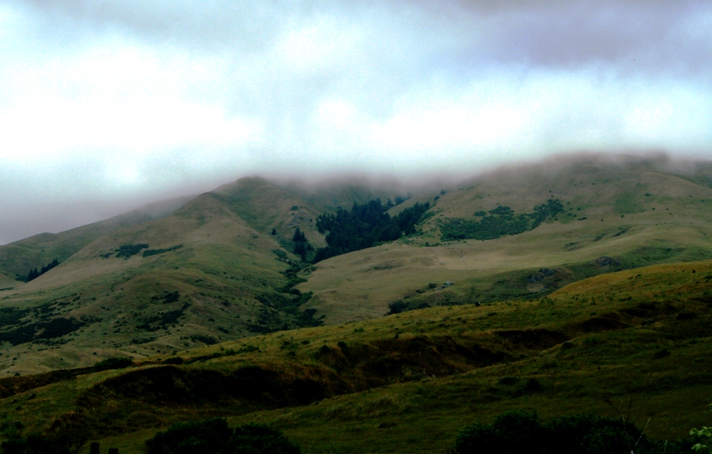
 Immediately, we climbed back to the mountain top and could see fog moving in. The terrain was mostly fields and ravines with a few trees until we cleared the top of the mountain range. 

After the summit, the fog hit and we crawled along for a couple miles, then it cleared as fast as it came. We drove back to Fortuna and back to our RV, and were impressed at the great variety of terrain we had been in during the past few hours.

Tuesday, June 26, 2012

The Avenue of Giants -- the Amazing Giant Redwoods

 While we stayed in Fortuna, CA, we made sure to drive the 30 mile "Avenue of the Giants" which passes right through an amazing stand of giant redwoods near the Pacific coast in northern California.

 We have certainly seen pictures of these huge trees, but you really can't realize the size of the trees until you get right next to them. Here, Rick and Orinda stand next to some huge tree trunks as the trees soar over 300' high.

 Today, most of this area is protected as a state park, however, this was not always the case. Indeed, back in the 1950's, this location was a thriving small town called Dyerville. Unfortunately, a huge flood in 1964 wiped out the town when the Eel Rvier seen here crested 42' above normal.

 We saw this high water mark sign on the road and were surprised to realize it was about 15' above the road, which was quite a ways above the river bottom. This was a huge flood!

 The trees are hard to fathom ang there are all kinds of attractions as a result. One interesting item is this Log Truck which was made out of 1 huge log back in the 1916 time frame.

 Of course, one of the most popular attractions is one of the three, privately owned drive-through tree. Rick had to do this, so he paid his $6 and Orinda took pictures. As he eased toward the opening, he started to have second thoughts.

It turns out that the Buick is a pretty big car when you drive it through a tree trunk! Rick eased through, but only had an inch or so on each side of the mirrors. Orinda figured that he was going to scrape the side, but good; however, he made it with no problem -- but he declined to do it again! Notice that the tree is 275' high and some 5,000 years old. Wow!

Another interesting attraction is this real "tree house"! This house is actually located in the base trunk of one tree as Orinda shows. The house has windows cleverly inset into the side. 

The inside of the tree house is really rather comfortable. It offers a dry area and it is an interesting view to see the inside of the trunk of a great tree. It was hard to believe we were actually inside a single tree!

What an amazing day in the Avenue of the Giants!

Sunday, June 24, 2012

Orinda visits Orinda, California!

Orinda has always wondered about her namesake, Orinda, California. We were surprised to find out that it was not that far away, so after a great visit to the Fisherman's Wharf area, we headed through downtown San Francisco on our way to Orinda, CA.

 There are many remarkable buildings in San Francisco and of course, most are relatively new given the terrible earthquake in 1906. While the traffic was very heavy, we had no real problem cutting through the downtown area.

Orinda is located to the east of San Francisco, past Oakland, CA. We took I-80 across the Oakland Bridge which is some 4.5 miles long. Unfortunately, we were on the lower level, so could not get a view of the harbor, or upper bridge area. 

 After a few more miles, we finally came to Orinda, CA and took the exit into this bedroom community of San Francisco.

 We learned that Orinda was named after an Englishwoman in 1876. The community started as a ranch, then in the 1920's, the town was established. Our Orinda was happy to checkout her namesake town, and while the town was nice, she decided to stay in her motorhome for now.

Heading north on I-580 after leaving Orinda, we crossed the last of the three major bridges in the San Francisco bay area and headed by to our RV park in Petaluma, CA. It was a long day, but we had a great time.